2nd Annual Colorado Jeep-CJ.com Trail Report

2nd Annual Colorado Jeep-CJ.com Trail Report
I'm sure you know you can click on the bar at the top of the picture to make it a little bigger but I don't like this web site's "feature" to downsize images. Even at full size the images in our gallery are not very big and fit just fine on a laptop display with only 1024x768 resolution.

As a matter of fact the full size image downloads to our PCs and then you can see the images resize so this "feature" doesn't even help with download speeds.

Ya clicking on the image bar helps a little, but it would be awesome to have the full screen images.. I have a 17" screen, heck I have a 32" screen on my wife's computer! How awesome it would be to look at the photos on that!
 
I hope the thread CJ puts together can show full screen size photos of this trip... It's hard to see the details! I can't wait to go with you guys next time!

I'm sure you know you can click on the bar at the top of the picture to make it a little bigger but I don't like this web site's "feature" to downsize images. Even at full size the images in our gallery are not very big and fit just fine on a laptop display with only 1024x768 resolution.

As a matter of fact the full size image downloads to our PCs and then you can see the images resize so this "feature" doesn't even help with download speeds.

Ya clicking on the image bar helps a little, but it would be awesome to have the full screen images.. I have a 17" screen, heck I have a 32" screen on my wife's computer! How awesome it would be to look at the photos on that!
I resized the pics that Busa and IO took and started to make another gallery that just has the trail ride pics. The pics are much larger then the regular gallery permits. I'll post a link as soon as I get done.

As far as the resizing goes in the Jeep-CJ gallery, hard drive space on a server is pretty expensive. I settled on the size I did so that I coud allow some pretty detailed shots but still allow the hard drive not to fill up for a while... ;)
 
I'll put my stuff up on Photobucket this afternoon and post back on here when they're done. I put full-frame's up there.
 
Nice pictures!
I like this one. Looks like it was taken from Imogene Pass looking back at Black Bear Pass.
DSC_7570.jpg
The trail goes on the left side of this mountain.


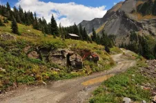
I also took a picture of this next cabin on Imogene Pass, but by that time it was raining on me and Larry. My picture was drab and didn't have as much color.
DSC_7600.jpg
Very nice!:notworthy:
 
Thank you BusaDave - we were lucky to have the weather we had that day.

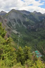
The first pick was indeed just heading out of Telluride on Imogene Pass. For those of you not familiar with the area, follow the switch backs up fro the bottom and where the trail disappears on the left you can just see the edge of a waterfall and the "steps" of Black Bear are just above it.

Yaaah no, you see, this is what I'm saying.. I don't see it! :(

Breathtaking pics, though... I can hardly wait to risk my life and drive down that!:eek:
 
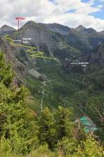
007 took a great picture of Black Bear Pass
11355d1347331408-2nd-annual-colorado-jeep-cj-com-trail-report-bb-pass.jpg

Photo by 007
In red is where Black Bear Pass reaches the highest point. It is 2 way at that point. Then it becomes one way. The yellow is the one way trail as it descends. The yellow is the hard part of the trail.
Here is Larry (IOPort51) at Ingram Falls
day2-054_black_bear_pass.jpg

day2-065_black_bear_pass.jpg

Then when the yellow stops (I hope you can still see the trail) this is 2 way. People can drive up to the top of Bridal Veil Falls from Telluride. There is a Power Station up there. Here is a pic of Bridal Veil Falls and you can see the old power station to the left (it's no longer used as a power station and it's now privately owned)
day2-076_black_bear_pass.jpg
 

Attachments

  • BB Pass.jpg
    BB Pass.jpg
    95.5 KB · Views: 5,868
Last edited:
Dave, I wish I was half the photographer you are.:notworthy:

the switchbacks were interesting but the rock ledges up around Ingram falls were what I will always remember, the voice in the back of my head was telling me that going off camber and straight (seemingly) down with a cliff face on one side and a whole lot of nothing on the other was insane and why was there no grad handle on the roll bar on the passenger side I could grab to keep from falling out the drivers door?:eek:
 
007 took a great picture of Black Bear Pass
11355d1347331408-2nd-annual-colorado-jeep-cj-com-trail-report-bb-pass.jpg

Photo by 007
In red is where Black Bear Pass reaches the highest point. It is 2 way at that point. Then it becomes one way. The yellow is the one way trail as it descends. The yellow is the hard part of the trail.
Here is Larry (IOPort51) at Ingram Falls
day2-054_black_bear_pass.jpg


day2-065_black_bear_pass.jpg


Then when the yellow stops (I hope you can still see the trail) this is 2 way. People can drive up to the top of Bridal Veil Falls from Telluride. There is a Power Station up there. Here is a pic of Bridal Veil Falls and you can see the old power station to the left (it's no longer used as a power station and it's now privately owned)

day2-076_black_bear_pass.jpg

Ok, now I see it... thank you for the diagram...:D
 
do the smart thing and learn how to use it before you go.:eek:


That was awesome... I am definately getting a video set up to mount on the Jeep, for when I get out there...
 
I cant think of any place in Iowa to practice driving in terrain like this so I guess you will have to get the hang of it when you get there.

you can take pictures anywhere.:laugh:


Are we talking about my CJ, or the camera?? :D
 
Great vid. :notworthy:
I could feel my brakes getting hot as I watched. :D
 
It was all mostly 1st gear -4 low. the camera never really shows the incline.
I am thinking of mounting an inclinometer someplace in the view of the camera to help with prospective on incline and camber.

this was one of the easier trails we drove but it was still an incredible ride.:cool:

I have about 3 hours of this yet to post. It is cool to just set and watch.:D


Great vid. :notworthy:
I could feel my brakes getting hot as I watched. :D
 
I cant think of any place in Iowa to practice driving in terrain like this so I guess you will have to get the hang of it when you get there.

you can take pictures anywhere.:laugh:

Oh ya, you laugh, but you have no idea how true that statement really is!! I was driving home from work today, looking out across the fields of corn and soybeans, and noticed one of the grain elevators off in the distance and was thinking to myself.. that's more than 12 miles, as the crow flys, from here!!! That, my friend, is flat!

If I drive a few miles south of my little town and look east, I can see the red flashing lights from the wind farm, more than 30 miles away! I am seriously incline challenged here in this state!
 
So have you been thinking about swapping out that T-150 ? Seeing that makes me really question if I want an automatic for myself as well. Im really thinking its T-18 time for both of us. :)

It was all mostly 1st gear -4 low. :D
 

Jeep-CJ Donation Drive

Help support Jeep-CJ.com by making a contribution.

Help support Jeep-CJ.com by making a contribution.
Goal
$200.00
Earned
$25.00
This donation drive ends in
Back
Top Bottom